4097 Diamond Hill Rd. Cumberland RI 02864 401-334-9996 Named for its mile-long face of veined granite quartz, Diamond Hill is a great place to do some mountain biking, jogging or hiking, have a picnic, and enjoy a free concert. The town of Cumberland sponsors a free Summer Concert Series in July and August. Climb to… Continue reading Diamond Hill Park & Bike Trail
Category: Activities
Round Top Brook and Management Area
1265 Brook Rd., Access Rte. 96, Burrillville, RI 401-568-9470 One of the smallest management areas in the state is mostly know for its fishing ponds. There are, however, a small network of trails on the property. Kayaks and canoes can easily be dropped in at Round Top, too! Seasonally stocked with trout; plenty of parking;… Continue reading Round Top Brook and Management Area
Pierce Park & Riverwalk
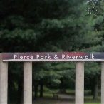
High St. Central Falls, RI 02863 401-727-8400 Site of Captain Michael Pierce’s fight with the natives as part of the King Phillip’s War in March of 1976, it is the city’s first riverfront park and includes a scenic overlook, riverbank walkway and recreational facilities. Pierce Park & Riverwalk
Killingly Pond Management Area
Snake Hill Rd. Glocester, RI 401-789-0281 396 acres of primarily forest and some wetlands. Covers a total land area of 396 acres. The area is primarily in forested cover types (deciduous 113 acres, evergreen 180 acres), with wetlands covering the balance of the acreage. Killingly Pond Management Area
Jenks Park
Broad St. Central Falls, RI 02863 401-727-7455 Built on land donated to the city by Alvin Jenks in 1890, the Park contains the Cogswell Clock Tower, erected in 1904. The Tower stands atop Dexter’s Ledge, which was used as an Indian lookout during King Phillip’s War in 1676. There is no charge to climb. Jenks… Continue reading Jenks Park
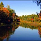
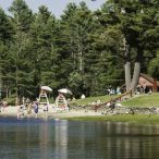
Georgiaville Pond Town Beach, Dam and Gorge
St. Michael’s Way, Smithfield, RI 02907 401-233-1051 Listed as one of the Seven Scenic Walks in Smithfield, Georgiaville Pond Town Beach, Dam and Gorge features a boat ramp, beach, fishing, high dam, spillway, gorge, huge old trees, picnic tables, benches, restroom facilities (open in summer). Renovated in 1991 with help from Open Space and Recreation… Continue reading Georgiaville Pond Town Beach, Dam and Gorge
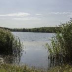
Fort Nature Wildlife Refuge
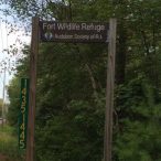
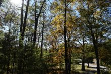
1443 Providence Pike, Rte. 5 North Smithfield, RI 02896 401-949-5454 Great place for a long hike through a variety of northern forest habitats at any time of year. This 235-acre protected chunk of North Smithfield is a destination for hikers and wildlife watchers. Fort is known for the beautiful beaver ponds teeming with animals and… Continue reading Fort Nature Wildlife Refuge
Durfee Hill Management Area
Reynolds Rd Glocester, Rhode Island 401-423-1920 Durfee Hill covers a total land area of 1176 acres. The area is composed of Primarily forest land (deciduous 726 acres, evergreen 201 acres), with wetlands (209 acres) and agricultural land (twenty-nine acres) accounting for the balance. Durfee Hill Management Area #outdoorrecreation
Chocolate Mill Overlook
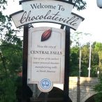
13 Charles Street, Central Falls, RI (Corner of Charles Street and Roosevelt Avenue) Blackstone Valley Tourism Council 401-724-2200 Chocolate Mill Overlook is a small pocket park located on the banks of the Blackstone River that celebrates one of North America’s earliest water-powered chocolate mills. The Overlook features: interpretive signs telling the story of early colonial… Continue reading Chocolate Mill Overlook
Casmir Pulaski Memorial State Park
151 Pulaski Road Chepachet, RI 02814 401-568-2013 Located within the 4000 acre George Washington Management Area, the 100 acre Pulaski Memorial Recreation Area is a “day use” facility offering users a multitude of opportunities to enjoy the outdoors. From the first class trout fishing in the spring, to enjoying a picnic, a short hike, or… Continue reading Casmir Pulaski Memorial State Park
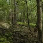
Blackstone Gorge
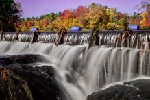
County Street, Blackstone MA 401-783-1500 This two-state park borders North Smithfield, Rhode Island and may be the most breathtaking section of the Blackstone River and its last wild stretch. Here you can stand on the rocky cliffs and look down into the river 80 feet below. Here the Blackstone River cascades over the Rolling Dam… Continue reading Blackstone Gorge
Audubon Society of Rhode Island

12 Sanderson Rd. Smithfield, RI 02917 401-949-5454 Environmental organization that manages the Powder Mill Ledges Wildlife Sanctuary, dedicated to the preservation of bird life. The refuge is the headquarters for the Society and offers a library, gift shop, teacher’s resource center, and bird-feeding station. Audubon Society of Rhode Island